I asked the helicopter pilot to fly to Hazor so that I could take video of the site. Before long we hovered over a modern town with houses, streets, and parks. The pilot and I exchanged awkward glances, and I clarified what I wanted: “I meant Tel Hazor.”
He still looked confused.
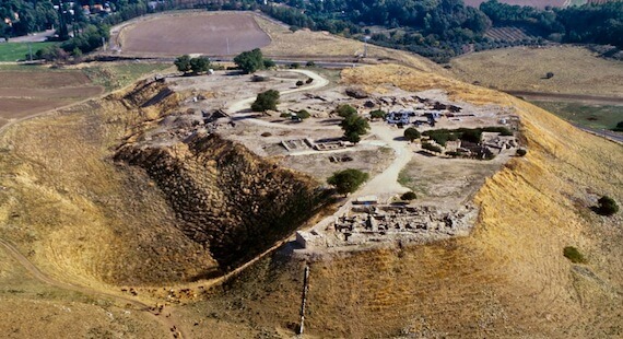
(Photo: Tel Hazor, courtesy of Pictorial Library of Bible Lands)
After five minutes of searching the area, we finally saw it. Two hundred acres huge, rising from the floor of the Huleh Basin, ancient Hazor looms as Israel’s largest tell.
I had to marvel at how times have changed. What was once Canaan’s most important city has somehow gotten lost in the weeds of contemporary minds.
How could the pilot not have known where it was?
Tel Hazor, Canaan’s Deadbolt in the North
Along the ancient international highway, geographical chokepoints required all travelers to pass well-fortified cities.
Among these, Hazor was the most important in northern Israel.
- All two hundred acres of Tel Hazor were occupied during the Canaanite period.
- Hazor stood as the largest city in Canaan during the Middle and Late Bronze Ages (2200-1400 BC).
- No one entered the land from the north without passing the site. I call it the “Deadbolt of Northern Israel.”
on my upcoming trip to Israel.
See the details, browse the tour itinerary, and
download a FREE brochure! After your journey to Israel,
you will never be the same!
The day I was at Tel Hazor, beautiful yellow flowers grew atop the tell. It struck me strange that life would blossom where so many people in history had died.
- Before the conquest under Joshua, “Hazor formerly was the head of all these kingdoms” (Joshua 11:10). Hazor was the only city Joshua burned in the northern campaign (Joshua 11:1,15).
- Modern archeologists have uncovered a Canaanite temple with a central niche where a male deity figurine sat on a throne.
- Stratum XIII of the tell had a large burn layer that corresponds with Joshua’s destruction of Hazor around 1400 BC.
- Two hundred years after Joshua, Hazor rose again to prominence during the years of the Judges of Israel. Deborah and Barak defeated Hazor’s general, Sisera, in the Valley of Jezreel and burned Hazor once again (Judges 4-5).
Hazor’s Gate, Déjà vu All Over Again
Because of the city’s strategic location, King Solomon later fortified Hazor’s well as Megiddo and Gezer (1 Kings 9:15).
- The tripartite city gates that Solomon built in these cities still stand.
- All three gates are nearly identical.
- During the time of the divided kingdom, the Israelites at Hazor dug a forty-meter deep shaft that reached the water table.
- The ruins include the Upper and Lower Cities, the stables, the water system, and the remains of Canaanite buildings.
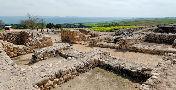
(Photo: Solomon’s gate at Hazor, courtesy of Pictorial Library of Bible Lands)
Across the street by Kibbutz Ayelet Hashahar, the Tel Hazor Museum offers explanations of the twenty-one occupation levels discovered during the tell’s numerous excavations. You can even volunteer to serve during the seasonal excavations.
The Deadbolt Gets Kicked In
As the first line of defense for the north, Hazor was also one of the first cities to fall when foreigners invaded, like the Assyrians (2 Kings 15:29).
- In 885 BC, Ben-hadad of Aram invaded Israel via Hazor.
- Under the boot of the Assyrian leader, Tiglath-Pileser III, Hazor was razed in 732 BC.
- It never recovered.
By the first century when Jesus passed Tel Hazor on His way north to Caesarea Philippi, Hazor stood as a mere police fort.
Today, even helicopter pilots struggle to find it.
Tell me what you think: Taking a high perspective, what can we learn from the fact the most important city of Canaan is now a mere hill with weeds? To leave a comment, just click here.
Hazor on the Map: